
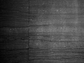


Hind Land is a collaboration between photographers Nick Rochowski and Tim Bowditch, surveying the pedestrian walkways beneath London’s Orbital M25 motorway. Since it’s completion 25 years ago the M25 has dramatically changed the landscape of the surrounding area and come to define the boundary of the city. Utilising online mapping tools to locate points at which one can pass underneath the motorway by foot, they are fascinated by the voids left by the motorway as it carves through the landscape. The road divides the countryside in two, leaving a visible and audible rip in the environment above the ground, and a no-man’s land beneath.
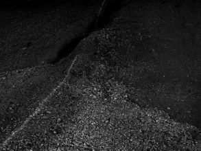
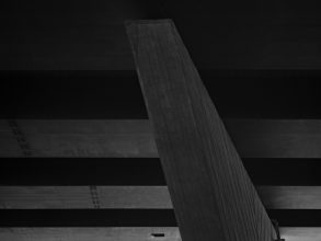
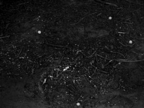
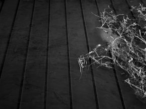
Together they aim to survey these voids at night, using an Achromatic Digital Back capable of creating wide spectrum black and white images. This kind of technology is often used for aerial surveillance, as it is able to record the visible as well as the infrared and ultraviolet parts of the spectrum. By photographing at night they give the camera a completely blank canvas, devoid of contrast. Due to the way light is recorded with such technology, hidden details become apparent and the landscape appears almost lunar in quality.
Artistic collaboration in Hind Land has also included artist Alison Moffett creating a drawing, and sound recorded and produced by artist Matthew de Kersaint Giraudeau.
Hind Land was recently presented at FORMAT13 photography festival in Derby, with at least three more European installations planned for the rest of 2013. Christiane Monarchi interviewed Tim and Nick about the background and inspiration to this collaboration.
———-
Christiane Monarchi: The start of your project I find quite engaging, in the description that your survey of the M25 motorway has focussed on underpasses that are accessible only on foot, an anachronism to the speed and access charted by the street planners. What attracted you to search out this type of non-place?
Tim Bowditch: Nick had already started an investigation into the motorway with his initial series ‘Immense’ (http://www.rochowski.net/filter/Work/Immense). He had begun looking at these locations where public footpaths intersected with the M25.
We came together after Nick saw ‘An Opposition: Bow’ (http://timbowditch.com/projects/an-opposition-in-collaboraton-with-david-angus/) a project in collaboration with David Angus whereby we walked the border of the E3 postcode with two cameras in opposition surveying the landscape.
We decided to use Nick’s project as a starting point and virtually drove the perimeter of the motorway using Google and Bing maps to drop pins wherever we saw whatever looked like a footpath intersecting the motorway. The idea was to create more of a survey like ‘An Opposition’. The only stipulation was that these were public access footpaths. We were not interested in lanes or roads.
We were interested in capturing these new subterranean environments created by the M25. Environments that are alluded to by the small access points as viewed on an aerial map but that the motorway has masked over the past 25 years. It became exciting and intriguing to imagine what lay at each point we dropped and the only way to ascertain what was there was to visit them.
Nick Rochowski: It’s that idea of seeing a barrier and then wondering what’s beyond it. Viewing on Google Maps gives you this overall image that is very stark and apparent. The methodology to our research and planning reinforce the survey aspect of our work. We’re not documenting in the traditional sense, we are exploring and analysing surfaces, scale and the layers of space.
Something that I’ve often said about this project is that it is in some way archaeological, the idea that these non-places are preserved areas of the landscape from before the orbital was built. Of course there probably has been some landscaping and specific tunnelling but in many cases we have been beside a river or stream and always on public rights of way. These places have a special significance as they exist at the axis of the border between inner and outer. This hind land collects ephemera from the world above and outside, shows weathering and evidence of passage.
CM: In planning your trip around the M25, were there any areas that were not properly charted or had ambiguous access, or were the online tools you used completely up to date with the physical locations? Were there some points that were difficult or more dangerous to reach?
TB: I remember virtually driving around the motorway on Boxing Day 2011 as it was more stimulating than the television. Nick had already dropped some pins for locations he visited in ‘Immense’, this was the starting point. Pins were dropped at any point (other than roads) that appeared to cross under the motorway. Together we then refined the map and categorised each point by type, i.e stream or tunnel. We ruled out ones which were obviously only streams with no possible way of access by foot and used the isometric view on Bing Maps to try and look into the environments from the side to ascertain if access was possible and guess what may lay beneath.
We then had to make sure these were accessible in terms of driving to a nearby point, parking, and walking across public access land. We tried to gauge the season the map images were captured and then work out what the landscape would be like in January (when we made the work).
The online research was key in filtering the locations initially, however the only way to find out if a location was accessible was to drive there. We visited about 12 locations in the end and only one of them turned out to be a 1 meter wide hole for a stream to pass that was definitely not accessible. Sometimes we had to walk for about 15 minutes from where we had parked to access a location and one location near Heathrow required a lot of fighting through undergrowth and climbing fences.
NR: The 12 locations were from our list of about 70, and from this there may have been 25-30 that were potentially usable but we aren’t to know for sure. We also split the locations into either NW, SW, NE, SE and then we could use this to help zone them efficiently. Whether or not the maps were up to date didn’t affect the research. The only thing to assess in that aspect was how dense foliage might be as a lot of the maps are done in what appears to be spring or summer and we were shooting in winter.
As Tim says, the only way to know for sure is to go to the location which is the exciting bit. But you can get quite detailed views on Bing/Google Maps and after we had visited some in the flesh we could then refer back to the map and re-evaluate the prospects for certain locations based on our experiences. Of course, when you get out there and you are driving to get to the place we have planned to park, it becomes much more reactive to the situation. The Heathrow location was a bit ambiguous. The access point was blocked off by a dirt mound, so we had to park further away and then walk back to it before commencing climbing through the foliage. There were signs warning of army/police patrols and it felt like we were treading on dodgy ground, despite the assurances of our research!
CM: I see from looking at some of Nick’s previous work on caves and liminal places an interest in recording scenes heightened with the danger of darkness and hanging around in otherwise deserted non-places, how does your work under the M25 compare to previous experience?
TB: I had not really made work in this way before so it was a new experience for me. I think collaborating on this project certainly helped as being in some of these places alone for two hours would have been quite uncomfortable. There was definite signs of very recent human activity at a location near Heathrow and we were both keen to get out of there quickly.
Some of the locations offered opportunity to think with the meditative hum of traffic allowing time to pass unnoticed.
NR: A lot of artists work solo when they are actually doing the work, and during shooting some of those previous projects I spent a lot of time alone in a cave or woodland. It can be an unnerving experience because its dark or you’re 300m inside a foreign hill, but I was safe in the knowledge that I was in fact alone.
We would joke that some of these border lands were perfect places to dispose of bodies! In the day you can see clearly the random houses, driveways, golf courses and farms. At night its very different, but the majority of the time was spent sitting underneath the motorway. Sometimes we were on a steep, slippery bank for a few hours which wasn’t much fun. When we were working with Matthew de Kersaint Giraudeau in 2012, he would be making sound recordings for long periods which meant keeping very quiet for long periods. The acoustics were really powerful in some locations.
Our methodology of researching in the day, testing shots, critiquing compositions and ideas meant that we were quite efficient and in the end just had to spend the time waiting for the exposures to complete.
CM: Seeing Tim’s previous collaborative projects like Pine and Storm Mountain which combine sound and image, I am intrigued by the current collaboration with Matthew de Kersaint Giraudeau. Hearing his sound recordings from the M25 underpasses activates a haptic sense to the black and white tableaux, and almost animates them, as one considers the duration of time spent watching and listening. How will you communicate this feeling to the viewer of your works in the gallery?
TB: The collaboration with Matthew became key as ideas for installations for the work developed. The sound at the very first location we visited which incidentally also features in ‘Immense’ was the catalyst for inviting Matthew to record sound on location with us. At this particular location we were able to walk up a bank and situate ourselves right under the motorway with vehicles passing about 2 meters above us. The underlying bass rumble was fully immersive and was penetrated by a high pitched ‘whoosh’ each time a car passed.
We knew we would not be able to capture this ourselves so asked Matthew, whom I have worked with for a few years to record sound.
To date we have been restricted to playing the recording on headphones in the gallery space due to the nature of being in group shows. However we have a solo show in Rome in May and one at Troika Editions Front Room Gallery in London in June so will be able to present the work as intended. The images will be shown as large scale floor to ceiling images encompassing a dimly lit room with Matthew presenting the sound as a fully immersive four channel installation, projecting an experience akin to being in the underpasses at night.
CM: How did you decide on the camera you used, the Arca Swiss RL3D? An achromatic digital back is not something we read about often, and I understand it can record frequencies beyond the visible spectrum, like infra-red; how does this type of technology translate into the images you have created?
TB: The camera itself is Nick’s and the same he uses for his commercial work.
At the start of the project we decided to record these scenes in black and white. The idea was to survey the environments devoid of any distractions including colour and really focus in on the elements of the locations that caught our attention on approaching blind from the footpaths. Another rule set was to not be seduced by the scene looking out of the tunnel, or of the motorway intersecting the landscape illuminated by the sun as Nick had previously explored.
Shooting at night meant we had a level playing field without contrast and variables that daylight and different times of day bring. However to shoot at night with very little ambient light from street lamps etc seeping in we needed the technology to do so. We had read about the Achromatic back and managed to get one on loan from Nick’s equipment supplier.
The images we created would simply not be possible if shooting on film or indeed with a regular digital bayeux pattern sensor. The sensitivity of the purely black and white back meant we could give the camera a blank canvas, and let it draw from it what it could, effectively scanning the landscape. The results were always a surprise as the camera picked up information from the spectrum that the eye cannot see and also read through the surface of water picking up the details on the bottom of streams.
NR: Using the RL3D formed a good technical foundation for our work as the process of using it isn’t fast…much like large format photography. A ground glass is used to compose, but then we would do high iso test shots to refine this composition. A laser is used to calculate focus.
The sensitivity was amazing. Even shooting similar-length exposures on a regular digital back would never be able to create the same images because of the camera’s ability to capture UV and IR light waves. The images have a lunar quality and that comes from this wide spectrum ability, and as Tim says it can see things you can see with the naked eye. We would never know what the final image would look like until the exposure was finished.
The process of shooting in the dark to let the camera gather information really ties into the survey element. We leave it to find what it can in the surfaces and negative spaces. The fact that the digital back doesn’t interpolate the data like a bayeux pattern array means we get raw clean information and as such the images are incredibly sharp, noise-free and detailed.
CM: The subjects in your photographs have endured up to an hour of exposure time for your images, the stillness is almost palpable. Was there any movement that has been and gone in that time, buried within the duration of the shot?
TB: These locations are generally uninhabited at night, mainly used for access during the day but devoid of any human presence at night. The only movement present is the water passing under some tunnels and this is obviously ‘smoothed’ out by the long exposure. There are no layers of human activity masked within the photographs which is interesting contrasted with frantic movement and rapid passing of human activity above. However ephemera from above such as golf balls carried in the stream do appear in images.
NR: Everything down there is in a sort of cryostasis, the changes are interminable but they do happen because you see the foreign elements in our photos. We capture what’s there and the effects of what has happened there.
CM: Could you tell us about the further collaborative element of Alison Moffett’s drawing, which could appear to be an abstracted map?
TB: We wanted to produce a publication to mark this year’s exhibitions of the project but we were reluctant to see the project in book form. The images, for all of their hidden detail, need to be viewed on large scale and the book format seemed too restricting in this respect. I found an original copy of the 1986 Ordnance Survey Map of London which was the first London OS map to include the completed motorway. We used this as the basis for the design of the publication and decided we could present the work as a map with a fold-out image which could be viewed as a large poster on one side and a map relating to a our research and field recording on the other.
I had come across Alison’s drawings via Nick and immediately thought she would add an interesting element to the project. We supplied her with information of the project and our coordinates for her to make a drawing, not necessarily a map, in response. Those were the only parameters set and we were very excited to see her response, a map but a defunct map with no scale or points of reference. The map becomes partially useful when our coordinates are entered into Google Maps but there is still an ambiguity about which points relate to which on the map and indeed to which photograph from the series.
CM: Images of the underpasses attest to the solid materiality of the structure, and also the lack of human element – I would have expected a lot of graffiti, rubbish, camps, other traces of life – did you expect to find such empty spaces?
TB: Indeed, these are the first things you think about and we did experience such elements on arrival at each location, however one of the many rules from the project was to avoid such humanising features and focus on the defining elements of each environment. The almost lunar quality of the first images we saw on the back of the camera led us to intentionally seek compositions without traces of life in order to create this idea that these subterranean landscapes are unvisited and unaffected, far removed from the world above.
NR: You can’t believe some of the places people managed to put graffiti on…they must have had scaffolding! It would have become a distracting part to the project and there was enough without it to be able to shoot. You can see elements of it in some of the images though, so its not completely avoidable. And as mentioned earlier, things from the world above do collect below especially in the streams.
CM: Is this a completed journey around the M25? If so, what do you have coming up next? I am interest in knowing about your future collaborations.
TB: We have not managed to visit all of the locations we pinpointed which is frustrating as the excitement of ‘unearthing’ each location researched online becomes addictive.
Unfortunately we ended up becoming constrained by the technology we were using and as it was on short term loan we had to complete the project in a month. Our journey is therefore complete but we did manage to visit locations all over the M25.
We are currently in the process of showing the work as an installation with sound and the accompanying map at various exhibitions this year. The work was recently show in Derby as part of Format Festival. We have a solo exhibition at 28 Piazza di Pietra in Rome from 17th May – 31st July (PV 16th May) which will include 6 large scale prints as well as a 3×6 meter wall piece in the underground level of the gallery and sound installation.
As part of Format we were presented with the Troika Award so have an exhibition at Troika Editions Front Room Gallery in London from 5th – 30th June (PV 4th June) and will be showing five floor-to-ceiling, wall-to-wall images fully encompassing the dimly space again with a sound installation by Matthew.
We have also been invited to be in an exciting group show at Bluecoat Gallery in Liverpool at the end of the year so will be working towards another installation there.
Nick and I are planning to start researching our next project later this year. The subject is unknown but we are interested in more sculptural elements and the final installation is also an important consideration from the start as it was with Hind Land.
It is exciting to see duos such as Taiyo Onorato & Nico Krebs picking up the Foam Paul Huf award as well as WassinkLundgren and Inka Lidergard & Niclas Holmstrom constantly producing interesting work and obviously Adam and Oliver being nominated for Deutsche Borse too. It is inspiring for us as although we will continue to make work individually we will definitely continue our collaborative practice via the platform of Rokov which Nick setup.
NR: -Yep, not much more to add to that. This year has turned out to be very busy with Hind Land which is great as we also had a really good response with a lot of curators in Arles 2012. So it would be also great to see the work in festivals and galleries in other countries.
Thinking about our next project is very exciting and as Tim said we are moving towards more sculptural/still life elements, there’s a lot of great collaborative projects being noticed out there at the moment. The great thing is that with Rokov we have already published a number of limited edition books and this avenue also offers interesting prospects for different kinds of projects in the near future.
———-
For further reading: